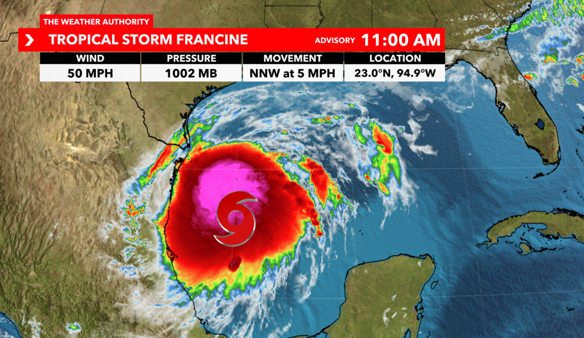
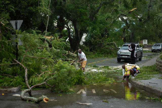
As Tropical Storm Francine forms in the western Gulf of Mexico, it brings a renewed focus on the hazards associated with Atlantic hurricanes. Francine, the sixth named storm of the 2024 Atlantic hurricane season, has emerged as a significant weather event, poised to impact the upper Texas and Louisiana coasts. This blog will provide an in-depth analysis of Francine’s formation, current status, forecast track, and potential impacts. We will explore the storm’s evolution, its expected effects, and offer preparedness tips for residents in the affected areas.
Formation and Current Status
Tropical Storm Francine was officially designated by the National Hurricane Center (NHC) on Monday morning, marking its entry into the 2024 Atlantic hurricane season. This storm is notable for being the first Atlantic storm in nearly three weeks, following Hurricane Ernesto’s move into the North Atlantic Ocean on August 20. The absence of significant tropical activity in the Atlantic Basin during this period is a rarity, with the last such occurrence noted in 1968.
Current Position and Movement
As of the latest update, Tropical Storm Francine is located approximately 400 miles south of Cameron, Louisiana. The storm is moving slowly north-northwest, with its forward motion expected to increase as it nears the coast. The system has a current intensity of 50 mph winds, and it is forecasted to strengthen as it tracks over warm Gulf waters. These conditions are conducive to further development, although the storm may face some challenges from wind shear and drier air near the Gulf Coast.
Rainfall and Coastal Impact
Currently, most of the rain associated with Francine remains offshore. However, outer bands of the storm have started to impact parts of South Texas, leading to minor coastal flooding. Tidal gauges along the Texas coast from Port O’Connor southward have recorded some elevated water levels. As the storm progresses, the potential for more substantial rainfall and coastal flooding will increase.
Forecast Track and Intensity

Tropical Storm Francine is projected to strengthen into a hurricane before making landfall somewhere along the Louisiana or upper Texas coast on Wednesday. The forecast models indicate that the storm will move over a pool of very warm Gulf waters, which will likely contribute to its intensification. However, the system might encounter increasing wind shear and possibly some drier air near the Gulf Coast, which could limit its maximum strength.
Projected Path
The exact landfall location remains uncertain, but the storm is expected to track slowly northward through Wednesday evening. Early predictions suggest that Francine could make landfall near Intercoastal City, Louisiana, in Vermilion Parish. As the storm approaches, its impacts will be felt across the Texas and Louisiana coasts well before the center reaches the shore.
Intensity Forecast
The current forecast suggests that Francine will reach Category 1 hurricane status by landfall. However, there is a possibility that the storm could strengthen to a Category 2 hurricane, depending on the atmospheric conditions it encounters. The storm’s intensity will be influenced by the warm Gulf waters, which provide ample energy for strengthening, and the potential for wind shear and dry air, which could inhibit further intensification.
Watches and Warnings
In anticipation of Francine’s impacts, several watches and warnings have been issued:
- Hurricane Watch: A hurricane watch is in effect from Cameron to Grand Isle, Louisiana. This watch indicates that hurricane conditions are possible within the next 48 hours. Residents in these areas should be prepared for the possibility of hurricane-force winds and other related hazards.
- Storm Surge Watch: A storm surge watch has been issued from High Island, Texas, east of Galveston Bay, to the Mississippi-Alabama border. This includes Vermilion Bay, Lake Pontchartrain, and Lake Maurepas. A storm surge watch means that life-threatening storm surge is possible in these areas within 48 hours.
- Tropical Storm Watches: Tropical storm watches are in effect from northeast Mexico to Port Mansfield, Texas, and from east of Galveston Bay to Cameron, Louisiana. Additionally, tropical storm watches are in place from near Grand Isle, Louisiana, to the Louisiana-Mississippi border, including Lake Pontchartrain. These watches indicate that tropical storm force winds are possible.
Potential Impacts

1. Flooding Rainfall
One of the most significant threats from Tropical Storm Francine is the potential for heavy rainfall and flooding. The storm is expected to bring substantial rainfall to the affected regions, with totals ranging from 4 to 8 inches. Localized areas, particularly from far northeast Mexico to the southern Texas coast, southern Louisiana, and southern Mississippi, could receive up to 12 inches of rain.
The heavy rain will fall on already saturated soils from recent rainfall, increasing the risk of flash flooding. The rainfall will spread across other parts of the South, reaching as far north as the mid-Mississippi and Ohio valleys by the end of the week. Residents in these areas should be prepared for localized flooding, which could be exacerbated by the storm’s outer bands.
2. Storm Surge
The potential for storm surge is a major concern with Tropical Storm Francine. The National Hurricane Center has forecast that peak inundation could reach 5 to 10 feet in parts of southern Louisiana, including Vermilion Bay, if the storm surge coincides with high tide. This surge could inundate low-lying coastal areas, causing significant flooding.
Residents in the affected regions should be prepared for life-threatening storm surge conditions and follow evacuation orders if issued. The surge will likely build and impact coastal areas along the upper Texas and Louisiana coasts beginning Tuesday night.
3. Winds
Hurricane conditions are expected to reach southern Louisiana by Wednesday afternoon. Tropical storm force winds could begin as early as Wednesday morning. These winds are capable of causing extensive damage, including downing trees, damaging structures, and leading to widespread power outages. Residents in areas under hurricane warnings should complete all preparations by Wednesday morning to ensure safety.
Power outages are a significant concern, with the potential for outages lasting several days in some areas. Residents should prepare for these disruptions by having backup power sources and stocking up on essential supplies.
4. Tornadoes
Landfalling tropical cyclones often produce tornadoes, and Francine is expected to follow this pattern. There is a potential for isolated tornadoes to develop, particularly in southern Louisiana, southern Mississippi, southern Alabama, and the western Florida Panhandle. The tornado threat may persist along the northern Gulf Coast and spread as far north as the Tennessee Valley by Friday.
Residents should remain vigilant for tornado warnings and be prepared to seek shelter if a tornado warning is issued. The risk of tornadoes will increase as the storm approaches and makes landfall.
Historical Context
The formation of Tropical Storm Francine is historically notable. It has been 30 years since the Atlantic Basin experienced a full week in early September without any active tropical cyclones. According to WPLG-TV hurricane expert Michael Lowry, this is a rare occurrence. Phil Klotzbach, a tropical scientist at Colorado State University, notes that the last time the Atlantic Basin went from August 13 to September 8 without any storms forming was in 1968.
This historical context highlights the significance of Francine’s formation and the unusual gap in tropical activity during the past few weeks. It underscores the importance of staying prepared and informed, even during periods of relative calm.
Regional Impacts
Lafayette Parish
Lafayette Parish, located in southwestern Louisiana, is under a hurricane watch. This means that hurricane conditions are possible within the next 48 hours. Tropical storm force winds are expected to impact the area beginning Wednesday morning and continue into the early hours of Thursday. These winds could reach gusts of 65 mph, potentially causing significant damage.
Rainfall in Lafayette Parish is likely to begin Tuesday afternoon, with increased chances of excessive rainfall and rapid flooding on Wednesday. The area could receive between 6 to 8 inches of rain, with isolated amounts up to 12 inches possible. Residents should finalize their storm preparations and consider evacuation options if necessary.
Vermilion Parish
Vermilion Parish is also under a hurricane watch. Tropical storm force winds are expected to impact the coastal areas of the parish with a 70-80% chance of occurrence. As Francine continues to strengthen and approach the coastline, these probabilities are likely to increase. The storm surge is estimated to reach between 5 to 10 feet, exacerbating coastal flooding concerns.
Residents in Vermilion Parish should prepare for significant impacts, including strong winds, heavy rainfall, and storm surge. It is crucial to follow local advisories and take necessary precautions to ensure safety.
Preparedness and Safety Measures

Evacuation Plans
Residents in the affected areas should review and finalize their evacuation plans. It is important to consider whether to evacuate or stay at home based on individual circumstances and local guidance. If evacuation is necessary, follow the routes recommended by local authorities and make arrangements for transportation if needed.
Emergency Supplies
Prepare an emergency kit with essential supplies, including non-perishable food, water, medications, batteries, flashlights, and a first aid kit. Ensure that your kit is stocked with items needed for several days, as power outages and disruptions in services may occur.
Property Protection
Secure your property by boarding up windows, securing outdoor items, and checking for potential flood hazards. Ensure that your property is protected from strong winds and storm surge to minimize damage.
Communication and Updates
Stay informed by monitoring official weather reports and updates from the National Hurricane Center. Sign up for local emergency alerts and follow guidance from local officials. Keeping in touch with family and friends is also important during a storm to ensure everyone’s safety.
Post-Storm Considerations
After the storm passes, be cautious when returning to your property. Avoid driving through flooded areas and stay away from downed power lines. Follow local authorities’ instructions for safe re-entry and recovery efforts.
Conclusion
Tropical Storm Francine represents a significant weather event for the upper Texas and Louisiana coasts. With its potential to strengthen into a hurricane and bring heavy rainfall, storm surge, damaging winds, and tornadoes, Francine poses serious risks to the affected regions. Residents should stay informed, complete their preparations, and follow safety recommendations to mitigate the impact of this powerful storm.
As Francine continues its journey across the Gulf of Mexico, the focus will remain on monitoring its development, tracking its path, and assessing its impacts. By staying prepared and vigilant, residents can ensure their safety and minimize the risks associated with this significant weather event.


